The Boise area, also known as Treasure Valley, is home to a vast number of scenic hiking trails. Hikes range from walks through sagebrush-covered hillsides in the Boise foothills to saunters along creek and river canyon bottoms. Whether you are interested in a short hike to a picnic area or a stroll through a unique habitat, here are a few easy scenic hikes near Boise.
Sweet Connie
Location: Foothills of Boise
Mileage: 1.6 miles out-and-back
Total Elevation Gain: 300 feet
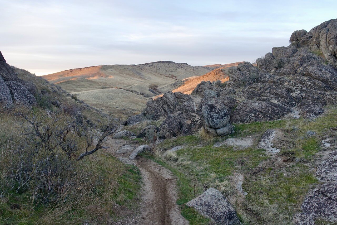
You can’t talk about the best hiking trails in the Boise Foothills without mentioning the Sweet Connie trail. The hike begins north of Bogus Basin Road and descends through sagebrush-covered hillsides. As you descend, picturesque outcrops become more prolific. The hike ends at the signed junction (0.8 mile) with Peggy’s trail, where hackberry trees, sagebrush, boulders and beautiful outcrops offer a scenic destination.
Although the hike is typically accessible year-round, it is best experienced during spring when the hillsides are green and wildflowers bloom or during fall with cooler temperatures and fall foliage. If you choose to hike in the summer, start early, as there is little shade until you reach the junction. From the junction, the hike can be extended by continuing up Sweet Connie trail (it becomes very steep within a mile) or meandering along Peggy’s trail.
Getting There: From the junction of Hill and Bogus Basin Roads, near downtown Boise, drive north on Bogus Basin Road for 5.6 miles and make an immediate right into the large parking area. The signed trailhead is on the opposite side of the road (north).
River Canyon Trail
Location: South of Kuna
Mileage: 2.0 miles out-and back
Total Elevation Gain: 50 feet
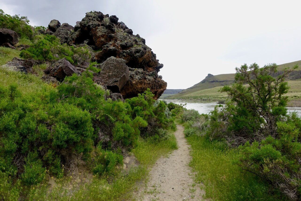
The River Canyon Trail lies within the Morley Nelson Snake River Birds of Prey National Conservation Area. This remarkable place is home to the greatest concentration of nesting birds of prey in North America–some say, the world. Around 800 pairs of eagles, hawks, falcons and owls arrive each spring to mate and raise their young within the crags, ledges and crevices of the canyon. The beautiful raptors soar within the canyon and hunt on the warm air currents rising from the canyon floor. A hike along the River Canyon Trail gives you the opportunity to see the birds in their scenic habitat.
This easy hike begins a few miles west of the historic Swan Falls Dam. The singletrack trail parallels the Snake River directly below basalt canyon walls that rise more than 400 feet overhead. A good destination is found at one mile, where the canyon widens and there is easy access to the river. The hike can be extended by continuing up the canyon nearly four more miles to Celebration Park.
Getting There: From Exit 44 on I-84 near Meridian, drive south on ID 69 for 7.9 miles and turn left on Swan Falls Road. Proceed another 20.1 miles and turn right on Swan Falls Shoreline Road. Continue 4.3 miles (the road transitions to a dirt surface) to the end of the road and signed trailhead.
Halverson Lakes
Location: Near Celebration Park, south of Melba
Mileage: 2.4 miles out-and-back
Total Elevation Gain: 100 feet
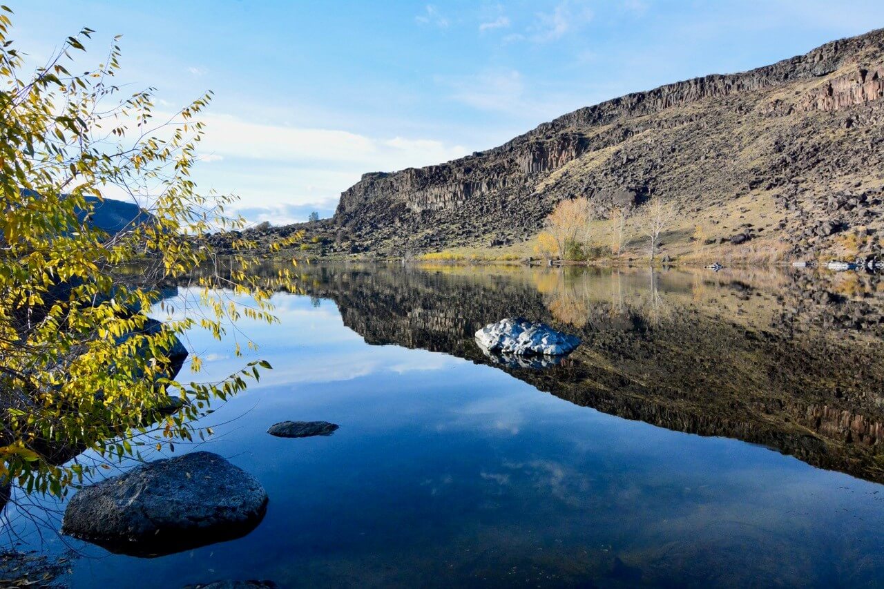
Located along the Snake River, Celebration Park is Idaho’s only archaeological park. The park has many attributes, including petroglyphs dating back nearly 10,000 years, the historic Guffey Railroad Bridge, campsites and a myriad of primitive trails. For an easy outing, try the scenic hike to Halverson Lakes.
The trailhead is found on the east side of the park and weaves between hundreds of auburn, gray and black basalt boulders, some more than 10 feet wide. The boulders are estimated by geologists to have been deposited here more than 15,000 years ago by the Bonneville Flood. The boulders are sometimes referred to as melon gravel, a name rumored to have been inspired by a roadside sign in Idaho labeling the unique rocks “petrified watermelon”.
The hike starts at the parking area and leads up a rough dirt road for a quarter-mile, then transitions to a singletrack trail. You immediately enter an area dotted with hundreds of melon gravel. As you continue along the trail, the melon gravel becomes larger and more impressive. Reach the first Halverson Lake just beyond a mile. An informational placard is located near the lake. The first lake is quite scenic as it is encircled by cottonwood and aspen trees, willows and other shrubs. The second lake is more like a pond and is often dry. There are several trails near the lakes enabling you to extend the hike.
Getting There: In Kuna, follow Swan Falls Road for 11.9 miles and turn right on Victory Lane. Continue on Victory Lane (the road transitions from Victory Lane to McDermott Road and then to Warren Spur) for 7.5 miles and turn left on Sinker Road. Follow this road 2.6 miles to the Guffey Bridge and entrance to Celebration Park. To find the trailhead, wind through the park for one mile to a large parking area just past the camping area.
Macks Creek
Location: Boise National Forest, east of Boise
Mileage: 3.0 miles out-and-back
Total Elevation Gain: 400 feet
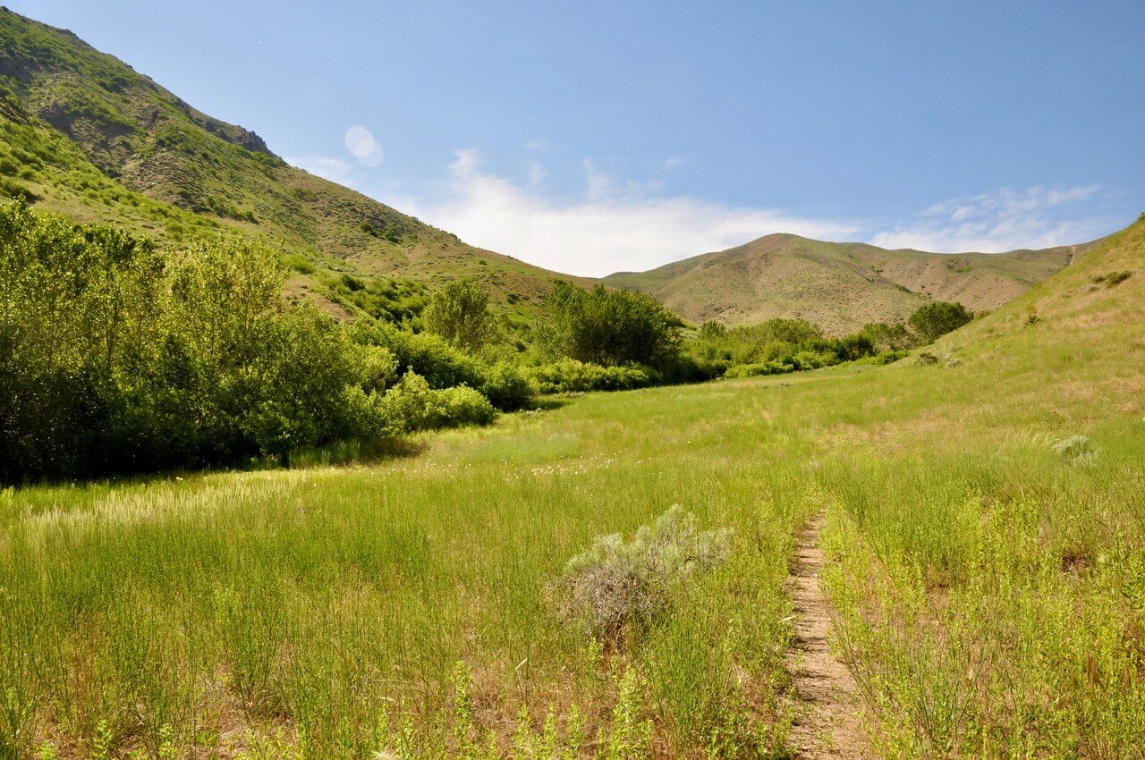
This little-known hike is located east of Boise, near Lucky Peak Reservoir. The hike is along an easy singletrack trail paralleling Macks Creek. The creek is lined with cottonwood trees, willows, alder and other shrubs—fine perches for songbirds. During spring, there are wrens, finches and mountain bluebirds (the state bird of Idaho).
The hike is usually accessible year-round, although the area is most scenic during late spring when the treeless hillsides are green, wildflowers bloom and the flora-lined Makes Creek comes to life. In winter and spring, elk and deer are often in the area during morning and evening hours. The trailhead is about a quarter-mile east of Macks Creek Park, a recreational area with picnic benches, sandy beaches, a boat launch and camping sites.
From the trailhead, the route heads north up a broad drainage. Just before a half-mile, the trail veers northwest below beautiful gray outcrops. Cross an intermittent stream at 1.3 miles, usually dry by mid-spring. At 1.5 miles, the trail fades at the end of the drainage. Several stands of trees offer a worthy picnic destination. Adventurous hikers can extend the hike by exploring (off-trail) one of the two steep ravines at the end of the drainage.
Getting There: From the junction of Warm Springs Avenue and ID 21, drive north on ID 21 for 9.3 miles. Turn right onto the paved FR 268. Proceed 4.9 miles to the unmarked trailhead on the left (north) side of the road.
These short hikes allow you to enjoy wonderful scenery and the opportunity to immerse yourself in the restorative powers of nature. Whether you walk a half-mile or ten, the most important aspect is opening your senses to the natural world. Happy exploring!
Feature image credited to Scott Marchant.
Scott Marchant lives in Boise and when not exploring the rugged diversity of Idaho, he strives to keep up with his active family. After exploring thousands of miles of trails Scott published several hiking guidebooks and hopes that others will see these remarkable places and then help to preserve and protect our public lands. Find more hiking trail details from Scott here.
Published on October 16, 2024